Third Consecutive Year Of La Niña Phenomenon: Should We Worry?
Between rains and droughts, this meteorological phenomenon begins to cause great damage among the countries of the region. Does climate change have something to do with this situation?

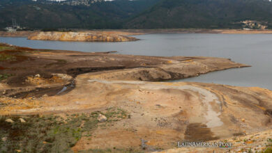
Photo: IDEAM
LatinAmerican Post | Christopher Ramírez
Listen to this article
Leer en español: Tercer año consecutivo con el Fenómeno de La Niña: ¿qué nos espera?
In Colombia, more than unusual, it is almost impossible to think that snow could fall, especially in places like its capital, Bogotá; For this reason, June 24, 2022 will go down in history as the day snow fell in central Colombia, with the Páramo de Sumapaz as the protagonist.
This town in the Colombian capital, considered "the rural area of Bogotá" , saw snow fall on its territory again after 60 years, which, of course, generated a whole 'boom', both among the inhabitants of the capital and in the rest of the Colombians.
So, if this was a "show" that is not usually seen very often in Colombia, why did it happen precisely this year?
According to the forecast coordinator of the Institute of Hydrology, Meteorology and Environmental Studies (Ideam), Luis Alfonso López , the snow in Sumapaz came due to "the significant decrease in temperature in the area, the significant increase in humidity and the development of cloudiness very close to the surface, which favored precipitation, when it exceeded the level of 0 degrees, to be solid reaching the surface”.
However, López put on the table a well-known term in recent weeks, not only in Colombia but in much of the region: the La Niña phenomenon, which in the case of the South American country has represented a significant increase in the accumulation humidity in much of the center of the country; but this weather situation is much more than just 'water harvesting'.
According to the World Meteorological Organization (WMO) , “La Niña is a phenomenon that produces a large-scale cooling of the ocean surface temperature in the central and eastern parts of the equatorial Pacific, in addition to other changes in atmospheric circulation. tropical, namely the winds, the pressure and the precipitations”, that is to say, it is a phenomenon that brings with it great climatic changes to the extreme: rains on the one hand and droughts on the other.
However, what has been considered in previous years as part of a natural cycle, since 2020 has shown a "tenacious persistence", according to the WMO. This UN agency added that the current episode of La Niña began in September 2020 and lasted until mid-May 2022 throughout the tropical Pacific area; although a new episode seems to have started in recent weeks, which has a 50% and 60% chance of continuing until July or September of this year.
YOU MAY ALSO BE INTERESTED IN: Gallery: Climate Change Records Broken In 2021
La Niña in Latin America
Now, there are forecasts that ensure that La Niña could extend even until 2023, which would mean having three winters in a row of this phenomenon, something that has not been seen since 1950; and although many experts assure that this is simply "a random climate problem", the truth is that others put climate change on the table as responsible, not only for the current situation, but for constant aftershocks in the future.
“We are increasing the chances that these triple events will occur,” said Matthew England, a physical oceanographer at the University of New South Wales in Sydney, Australia, in statements quoted by the journal Nature.
Of course, this fact has already affected not only Colombia, but a large part of the Latin American countries, since La Niña, according to Nature, causes the winds to strengthen throughout the Eastern Pacific, making this area much more cold and dry.
As explained by the World Wide Fund for Nature (WWF, for its acronym in English) , “the Eastern Tropical Pacific Ocean (OPTO) extends along the Pacific coast of Central America, from southern Mexico to northern Mexico. Peru”, this is more than 199 million hectares of coastal and marine habitats, as well as almost 21 million hectares of continental shelf.
For this reason, it is normal for this phenomenon to affect two large areas of Latin America in very different ways, taking into account, precisely, the location of the countries. The OPTO area has been plunged into heavy rainfall, so South American countries such as Colombia and Ecuador, as well as part of northern Brazil, have seen a permanence of the rainy season in their respective territories.
The same situation occurs in Central America with "rainier conditions than normal" in areas such as the border between Mexico and Guatemala, southern El Salvador, central Honduras and the Pacific coast of Costa Rica and Panama, according to data from the Committee. Regional Hydraulic Resources.
For their part, countries in the southern cone of the continent such as Peru, Bolivia, Argentina and Chile, have seen, contrary to their northern neighbors, prolonged droughts with occasional light precipitation in the highest territories of the Andes plateau.
At the moment, scientists do not dare to believe that this situation is the result of climate change on Earth, since there is still a lack of evidence and analysis to confirm this hypothesis, however, research continues and the results are increasingly close to giving this theory as a reality.